 |
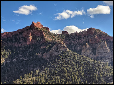
| Noah's Ark from Noah's Ark Trail Parowan Utah |
Noah's Ark Trail
- Parowan Utah in 360 Degrees -
 |
| Noah's Ark |
Immmersive Version for VR Headsets of my visit to this area on my Road Trip to Sedona and the Grand Canyon.
Use a VR Headset to Transport Yourself on a Road Trip to some Magical Places. First to Noah’s Ark, Vermillion Castle & Hidden Haven Waterfall in Dixie National Forest, then to photographers favorite viewpoints of Cedar Breaks National Monument & Horseshoe Bend. Then we will do a sunrise hike to DevilsBridge that looks like an entrance to a Fairy Kingdom, and then we will head to Fay Trail in the Secret Forest to see something magical. From there we will watch Sunrise over the Grand Canyon in the Spring from the Desert Watchtower. Our last spot will be journeying into the depths of the epic Buckskin Gulch slot canyon to find the Dragon. So what are you waiting for? Grab your VR Headset and transport yourself into this magical road trip with me that is sure to make you smile and give your day a positive boost.
Oculus Quest Headset Links
Direct Link
Oculus Portfolio Link for access to all my VR Nature Vacations
YouTubeVR Links Roadtripping to Sedona's Fairyland & Grand Canyon.
VR 360 Video of Roadtripping to Sedona's Fairylands & Grand Canyon.
If you are not watching in a VR Headset, make sure you move around so you can see everything, or put it in a Google Cardboard and the YouTube Mobile App so you can still be transported there. A Google Cardboard can be purchased for less than $10.
360 Video Of Noah's Ark Trail
Link for Noah's Ark Trail if Above is not working.
INFORMATION ABOUT NOAH'S ARK HIKE
- 3.5 Hours South of SLC by Parowan, Utah
- 3-4 Mile Hike
- About 1200 feet elevation gain
- Amazing Vista View Hike of beautiful Red Mountains and of course Noah's Ark.
- Bridge is washed out, so you need to cross on one of the trees across stream, or if you walk down to across from the little house and put on water shoes, you can just walk across here. The banks are not so steep that is it easy to cross. If you choose to cross on the logs, the one log is almost 2 feet in diameter, so it is plenty wide to safely cross. It is just higher up, and I am not a huge fan of that. The second log by the house is only about 1 foot in diameter, but it is not that high off the stream. Lots of options if you decide to brave crossing the stream and enjoying this hike. Just do something you feel safe with.
WHY DOES ALL TRAILS CALL THIS A HARD TRAIL?
All Trails calls this a HARD trail. When I see that, I just get a little frustrated for I want to know WHY. I have been on numerous hikes that were labeled hard that I did not think were hard. So here is my list of things I think make a trail HARD, and answers to those questions.
- Is it hard because of length or elevation gain? No. It is a lot of uphill, but it is not bad. Just take a short break if you get winded. You are pretty high in elevation.
- Is it hard because of bouldering or hiking maneuvers? No. There is no hard moves on this hike.
- Is it hard because of loose rocks on a steep incline? Maybe. Up at the top it is not bad to climb up, but remember you need to get back down. If you have poles, the small sections where there are a few loose rocks that are on a incline wouldn't be hard, but there are 2-3 about 10 foot sections that the trail is narrow, and the incline is a little steep that if you didn't bring poles it might not be bad to not finish to the end. The best views are not up close to the ark anyway. They are seeing it from afar.
- The bridge being gone I think also makes this a harder hike. If you are prepared though and have water shoes, and you cross down lower with your hiking sticks, I am not sure it really is that bad.
2D Video of Noah's Ark in Parowan Utah
360 View on Trail. Definitely Feels like a Top of the World Hike!
360 Video Noah's Ark Trail
 |
| Amazing Views from the Noah's Ark Trail. |
HOW TO GET TO THE TRAILHEAD - INSTRUCTIONS FOR HIKE
If you take exit 78 Parowan exit off I-15 and then take UT-143 S and turn on Bowery Creek Rd and watch for this Gate below. Google Maps did not get me here with its directions. I think I have fixed it, but just in case here is the coordinates of this gate.37°47'40.8"N 112°47'35.4"W
Bowery Creek Rd, Parowan, UT 84761
Google Map Link to Trail Head Location
 |
| Gate for Trail Head for Noah's Ark |
VIDEO OF THE THIS SPOT, the stream and options.
I crossed here, and it wasn't that bad, but I don't like crossing logs, so on the way back, I wondered what other options people have. If you walk the dirt road down to an old house, there the banks are shallow, the stream wider, and if you change from your hiking shoes to some water shoes, and use your poles, this is a good place to cross. It also has another log here you can cross that is not as wide, but it also is not that high above the water, and has branches to hold on to.
Location Coordinates of a good safe spot to cross the stream. 37.7951310, -112.7964840
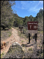
Once you get across the stream, the trail is heading off to the left. You want to watch for this sign below, and then you will know you are on the correct trail.
360 VIDEO to CAIRN SPOT
Once you get across the stream, the trail is heading off to the left. You want to watch for this sign below, and then you will know you are on the correct trail.
 |
| Noah's Ark Trailhead Sign |
 |
| Amazing Red Top Mountain you see often from Noah's Ark Trail. I think it is also looks like a ship in water. |
Videos of a Tricky Spots on the Trail. Don't head out in scary areas, make sure you look around to see if there is a switch back, and watch for Cairns if not sure.
2D Video of area to watch for Switchback.
360 Video of the spot you need to watch for the Cairns
360 VIDEO to CAIRN SPOT
 |
| Amazing Red Top Mountain you see often from Noah's Ark Trail. |
INSPIRATIONAL THOUGHT - How do some bloom in such rocky soil?
It amazes me when I see a flower like the one above, growing in a hot desert in an area just covered in tons of rocks. How did you grow little one? You are such a beautiful flower, but you survived in crazy circumstances. Some people amaze me just like this flower. They have trial after trial that just make it hard to be happy and bloom, but they still do. May we find those that are trying so hard to bloom but are trying to make it in really hard environments. Find ways to help them and love them so that they may have the strength to bloom and enjoy the sun.

Views along Noah's Ark Trail- Parowan Utah

360 Video Up by the Top of Noah's Ark - make sure you rotate it around to see it ALL!
WEIRD CREVASSES AT THE BASE OF NOAH'S ARK
At the base Noah's Ark there are caves and weird Crevasses. To me the one below looks like a but crack. Notice the wall of Noah's Ark has Round Rocks sticking out. It almost looks chiseled.
 |
| Butt Crack of Noah's Ark |
 |
| This one looks like a creatures mouth and eyes. |
 |
| Wall of Noah's Ark. Notice how the trail turns rocky up closer to the Ark, and how the Walls are created by those rocks cemented together. . |
 |
| Front section of Noah's Ark |
 |
| This is where I turned around on the trail. I was so close to the end, but I was not loving the steepness of the trail here heading down here towards the back of Noah's Ark. |
Do You Want to See More 360 Images On Noah' Ark Trail? Just Click on the Noahs Ark Google Earth Link, then click on the little dude in the bottom corner, then any blue dot to see more.
VERMILLION CASTLE AREA ACROSS THE ROAD FROM NOAH'S ARK IS BEAUTIFUL!
If you make it out here, my favorite part, was driving past the Noah's Ark Trailhead, for the views for the next few miles are extremely pretty. It has white cone like structures in front of Dark red cliffs. It is just really unique and interesting. Across the road from Noah's Ark is a trail called Vermillion Castle that also looks very interesting. If you look at the photos below, you can maybe see why this area is called a Castle area.
 |
| Vermillion Castle Area just up road from Noah's Ark Trailhead. |
 |
| Vermillion Castle Area just up road from Noah's Ark Trailhead. |

Views of Vermillion Castle just North East of Noah's Ark Trailhead.
If you liked this area, I think you will also LOVE
BALD MOUNTAIN
Also an amazing Vista View - Top of the World type Hike that has rocks along the trail that are so unique. There are rock walls, rock stairs, beautiful flowers growing next to pretty rocks, but the best part it you are so high up you can see 12 lakes around this area from this hike. Amazing Hike. Definitely Check it Out!
_______________________________________________
also
Double O Arch, Devil's Garden Primitive Loop
is a crazy cool hike. You walk on Rock Fins, and see 7 arches on one hike. You also have areas that you feel like you are on Top of the World and can see forever. Fabulous. Check it out in 360 Degrees.
Devils Garden Primitive Loop
________________________________________________
Island In The Sky - Gran View Point in Canyonlands
is also an amazing Vista View - Top of the World Hike. It is shocking to be so high and see birds fly below you . Amazing landscapes from so very high up.
_________________________
If you have enjoyed this post, please consider the following Sponsor Links.


